Install the app
How to install the app on iOS
Follow along with the video below to see how to install our site as a web app on your home screen.

Note: This feature currently requires accessing the site using the built-in Safari browser.
-
Follow us on Twitter @buckeyeplanet and @bp_recruiting, like us on Facebook! Enjoy a post or article, recommend it to others! BP is only as strong as its community, and we only promote by word of mouth, so share away!
You are using an out of date browser. It may not display this or other websites correctly.
You should upgrade or use an alternative browser.
You should upgrade or use an alternative browser.
Tropical Weather
- Thread starter Mike80
- Start date

Fungo Squiggly
Mortal enemy of all things Bucky
Yahoo Pickem Champ
Former Game Champion
'18 BPCFFB II Champ
'18 Keeper League Champ
Worst thing to happen to the Philippines since Tim Tebow.
Upvote
0
There is a town at the tip of the first island that this storm made landfall at which hasn't been heard from yet. It has a population of 45,000 and they aren't confirming if anyone was able to evacuate or not.
Originally the death tool was estimated at 1,200 but they have pulled that estimate back and are only saying it could be in the thousands now.
Originally the death tool was estimated at 1,200 but they have pulled that estimate back and are only saying it could be in the thousands now.
Upvote
0
So, 9 months form now we are going to see an "East Coast Baby Boom"?
As a matter of fact, yes.
http://www.usatoday.com/story/news/nation/2013/07/22/nj-sandy-baby-boom/2576741/
Upvote
0
The strongest Hurricane on record in the NHC AOR (Atlantic, eastern North Pacific) is making a beeline for the MExican Pacific coast:

Upvote
0

7:00 AM CDT Fri Oct 23
Location: 17.3°N 105.6°W
Moving: NNW at 12 mph
Min pressure: 880 mb
Max sustained: 200 mph
Upvote
0
National Hurricane Center said:ZCZC MIATCDEP5 ALL
TTAA00 KNHC DDHHMM
HURRICANE PATRICIA DISCUSSION NUMBER 14
NWS NATIONAL HURRICANE CENTER MIAMI FL EP202015
400 AM CDT FRI OCT 23 2015
Data from three center fixes by the Hurricane Hunters indicate
that the intensity, based on a blend of 700 mb-flight level and
SFMR-observed surface winds, is near 175 kt. This makes Patricia
the strongest hurricane on record in the National Hurricane Center's
area of responsibility (AOR) which includes the Atlantic and the
eastern North Pacific basins. The minimum central pressure
estimated from the aircraft data, 880 mb, is the lowest ever for
our AOR. It seems incredible that even more strengthening could
occur before landfall later today, but recent microwave imagery
shows hints of a concentric eyewall developing. If the trend
toward an eyewall replacement continues, it would cause the
intensity to at least level off later today. The official forecast
shows only a little more strengthening before landfall. Given the
very mountainous terrain that Patricia should encounter after
landfall, the cyclone should weaken even faster over land than
predicted by the normal inland decay rate.
***
FORECAST POSITIONS AND MAX WINDS
INIT 23/0900Z 17.0N 105.5W 175 KT 200 MPH
12H 23/1800Z 18.8N 105.4W 180 KT 205 MPH
24H 24/0600Z 21.7N 104.2W 60 KT 70 MPH...INLAND
36H 24/1800Z 24.5N 102.5W 20 KT 25 MPH...POST-TROP/REMNT LOW
48H 25/0600Z...DISSIPATED
$$
Forecaster Pasch
NNNN
http://www.nhc.noaa.gov/archive/2015/ep20/ep202015.discus.014.shtml?
Upvote
0
AuTX Buckeye
Founder & Pres of the Flemming/Holtmann Fan Club
Yahoo Pickem Champ
Former Game Champion
Here comes the rains folks... I've seen predictions as low as 2 inches and has a high as 15 between now and Sunday... with most saying between 5-10 inches of rain.
Upvote
0
ExpatAkronite
Cascadia Subduction Zone
Sustained winds of 200 MPH is--literally--off the fucking charts. This is going to be very, very bad.
Upvote
0
ExpatAkronite
Cascadia Subduction Zone
Patricia is packing a 40 foot surge. In comparison Katrina's was 28'.
Upvote
0
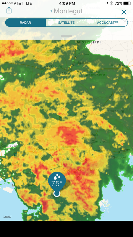
Nutriaitch
Retired Super Hero
this weather sucks!
been raining for about 36 straights hours.
just a steady, non-stop, driving rain.
radar says this is still going to last a while.
been raining for about 36 straights hours.
just a steady, non-stop, driving rain.
radar says this is still going to last a while.
Upvote
0