HURRICANE MATTHEW DISCUSSION NUMBER 12
NWS NATIONAL HURRICANE CENTER MIAMI FL AL142016
1100 PM EDT FRI SEP 30 2016
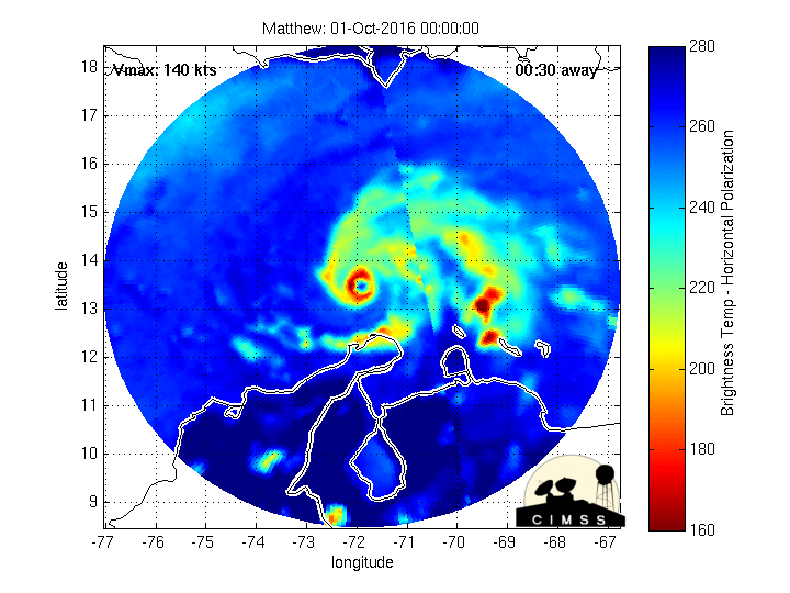
An Air Force reconnaissance plane recently measured a peak SFMR wind
of 143 kt and then 138 kt during this mission's eye penetrations.
Furthermore, the satellite presentation has improved considerably
with a distinct eye surrounded by a ring of very deep convection.
The raw objective T-numbers from UW-CIMSS have been above 7.0 since
2100 UTC. On this basis, the initial intensity has been increased to
140 kt, making Matthew a Category 5 on the Saffir-Simpson Hurricane
Wind Scale. This is the first Category 5 hurricane in the Atlantic
basin since Hurricane Felix in 2007.
Matthew probably is near its peak intensity and will likely maintain
a similar strength during the next 12 hours or so. Data from the
reconnaissance plane show an incipient outer band of maximum
winds, indicating that an eyewall replacement cycle could occur
soon. This should result in fluctuations in intensity, and given
that southwesterly shear is still affecting the cyclone, some
weakening is anticipated. However, Matthew is forecast to be a
category 4 hurricane by the time it moves near Jamaica and eastern
Cuba. Some additional weakening is expected over the high terrain of
Cuba. It is noted that none the guidance ever indicated the rapid
strengthening of Matthew.
Matthew is still moving south of due west or 265 degrees at 6 kt
steered by a strong high pressure system over the western Atlantic.
In about 12 hours, the hurricane should be on the western edge of
the high and ahead of a deepening trough over the Gulf of Mexico.
This steering pattern should force Matthew to turn northwestward and
then northward at about 5 to 10 kt. The track guidance has been very
consistent with this scenario, and there are no reasons to deviate
much from the previous NHC forecast. At the end of the forecast
period, when Matthew is expected to be in the Bahamas, the track
models are in less agreement with both track and speed, increasing
the uncertainty in the forecast. The NHC forecast follows closely
the multi-model consensus TVCN and TVCX.
It is important to remind users that average NHC track forecast
errors are around 175 miles at day 4 and 230 miles at day 5.
Therefore, it is too soon to rule out possible hurricane impacts
from Matthew in Florida.
FORECAST POSITIONS AND MAX WINDS
INIT 01/0300Z 13.3N 72.3W 140 KT 160 MPH
12H 01/1200Z 13.3N 73.3W 135 KT 155 MPH
24H 02/0000Z 13.7N 74.2W 125 KT 145 MPH
36H 02/1200Z 14.6N 75.0W 115 KT 130 MPH
48H 03/0000Z 16.0N 76.0W 115 KT 130 MPH
72H 04/0000Z 19.0N 76.3W 115 KT 130 MPH
96H 05/0000Z 23.1N 76.3W 90 KT 105 MPH
120H 06/0000Z 26.0N 76.5W 95 KT 110 MPH
$$
Forecaster Avila