
Install the app
How to install the app on iOS
Follow along with the video below to see how to install our site as a web app on your home screen.

Note: This feature currently requires accessing the site using the built-in Safari browser.
-
Follow us on Twitter @buckeyeplanet and @bp_recruiting, like us on Facebook! Enjoy a post or article, recommend it to others! BP is only as strong as its community, and we only promote by word of mouth, so share away!
You are using an out of date browser. It may not display this or other websites correctly.
You should upgrade or use an alternative browser.
You should upgrade or use an alternative browser.
Tropical Weather
- Thread starter Mike80
- Start date

Taosman;1245099; said:Spellcheck! It's your friend! :tongue2:
It was spelled right, it's just the wrong word.
That's what I get for not having a beer by 8 AM :p
Upvote
0
storm looks to be wobbling to the left a bit (the Taosman curve  ) and seems to be tracking nearly due west at the coast....
) and seems to be tracking nearly due west at the coast....
Upvote
0
Nutriaitch
Retired Super Hero
Can't believe they pinned the landfall 5 freaking days ago.
If your watching the Wether Channel, these people are all less than 30 minutes from my house.
If your watching the Wether Channel, these people are all less than 30 minutes from my house.
Upvote
0
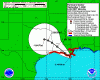
now a wobble to the north.
the current path should take it between 2 and 7 miles to the west of Houma....
the current path should take it between 2 and 7 miles to the west of Houma....
Upvote
0
Nutriaitch
Retired Super Hero
eye made landfall between Cocodrie and Montegut (my hometown)
that's about 15 miles or so south of Houma.
that's about 15 miles or so south of Houma.
Upvote
0
Nutriaitch;1245177; said:eye made landfall between Cocodrie and Montegut (my hometown)
that's about 15 miles or so south of Houma.
Yep....and Houma got the eastern eyewall (or what was left of it)...
000
WTNT42 KNHC 011454
TCDAT2
HURRICANE GUSTAV DISCUSSION NUMBER 32
NWS TPC/NATIONAL HURRICANE CENTER MIAMI FL AL072008
1100 AM EDT MON SEP 01 2008
THE CENTER OF GUSTAV MADE LANDFALL ALONG THE LOUISIANA COAST NEAR
COCODRIE ABOUT 1430 UTC. DURING THE PAST FEW HOURS...THE EYE
BECAME BETTER DEFINED ON RADAR. HOWEVER...WIND DATA FROM AIR FORCE
RESERVE AND NOAA AIRCRAFT ALONG WITH DOPPLER RADAR WINDS SUGGESTS
THAT GUSTAV WEAKENED TO A CATEGORY TWO HURRICANE BEFORE LANDFALL.
THE INITIAL INTENSITY OF 95 KT IS BASED ON THE AIRCRAFT DATA...AND
THIS MIGHT BE A LITTLE GENEROUS.
THE INITIAL MOTION IS 310/13. GUSTAV IS BEING STEERED NORTHWESTWARD
BY A MID-LEVEL RIDGE OVER THE EASTERN UNITED STATES. THE CYCLONE
IS EXPECTED TO CONTINUE NORTHWESTWARD WITH A DECREASE IN FORWARD
SPEED AS A LOW-LEVEL RIDGE BUILDS TO THE THE NORTH AND NORTHWEST.
THE FORECAST TRACK IS ESSENTIALLY AN UPDATE OF THE PREVIOUS
FORECAST THROUGH 48 HR. AFTER THAT TIME...THE GUIDANCE IS NOW IN
BETTER AGREEMENT ON A SLOW NORTHWARD MOTION...SO THE 72-120 HR PART
OF THE TRACK IS CHANGED FROM A WESTWARD DRIFT TO A NORTHWARD DRIFT.
GUSTAV SHOULD WEAKEN AS IT MOVES INLAND...ALTHOUGH THE WEAKENING
WILL LIKELY BE SLOW AT FIRST AS THE CENTER CROSSES THE SOUTH
LOUISIANA MARSHES. A FASTER WEAKENING IS EXPECTED IN 6-12 HR AS
THE CENTER REACHES MORE SOLID GROUND. AFTER 48 HR...GUSTAV IS
LIKELY TO SHEAR APART...WITH THE UPPER-LEVEL PORTION OF THE CYCLONE
MOVING NORTHEASTWARD AND LEAVING THE SURFACE CENTER BEHIND.
THUS...THE FORECAST SHOWS THE SYSTEM BECOMING A REMNANT LOW BY 72
HR.
THE THREAT OF HIGH STORM SURGE WILL CONTINUE ALONG THE LOUISIANA
COAST FOR SEVERAL MORE HOURS...AND THE THREAT OF HEAVY RAINS WILL
CONTINUE FOR SEVERAL DAYS.
FORECAST POSITIONS AND MAX WINDS
INITIAL 01/1500Z 29.2N 90.8W 95 KT
12HR VT 02/0000Z 30.3N 92.4W 70 KT...INLAND
24HR VT 02/1200Z 31.3N 93.8W 40 KT...INLAND
36HR VT 03/0000Z 31.9N 94.6W 30 KT...INLAND
48HR VT 03/1200Z 32.4N 95.3W 25 KT...INLAND
72HR VT 04/1200Z 33.0N 95.5W 20 KT...INLAND REMNANT LOW
96HR VT 05/1200Z 33.5N 95.5W 20 KT...INLAND REMNANT LOW
120HR VT 06/1200Z 34.0N 95.5W 20 KT...INLAND REMNANT LOW
$$
Hurricane GUSTAV Forecast Discussion
FORECASTER BEVEN
Upvote
0
Nutriaitch
Retired Super Hero
Talked to a good friend of mine who is still in Houma.BuckeyeMike80;1245227; said:Yep....and Houma got the eastern eyewall (or what was left of it)...
It got downright brutal.
No word on Montegut yet, but the surrounding areas are in bad shape.
Port Fourchon (farther East from me) reportedly has 9 feet of water.
That is a MAJOR port for the oilfield. Not good for Louisiana or the rest of the country for that matter.
Upvote
0
Nutriaitch
Retired Super Hero
So far, our levee is holding, but is pretty much at capacity.
Upvote
0
000
WTNT43 KNHC 011732
TCDAT3
HURRICANE HANNA SPECIAL DISCUSSION NUMBER 19
NWS TPC/NATIONAL HURRICANE CENTER MIAMI FL AL082008
130 PM EDT MON SEP 01 2008
THIS SPECIAL ADVISORY IS TO UPDATE THE INTENSITY OF HANNA. DATA
FROM THE AIR FORCE RECONNAISSANCE AIRCRAFT INDICATE THAT HANNA IS
NOW A HURRICANE WITH 65 KT WINDS. THE INTENSITY HAS BEEN ADJUSTED
UPWARD AT ALL FORECAST TIMES. THE TRACK HAS ALSO BEEN SLIGHTLY
ADJUSTED BASED ON THE LATEST FIX. THIS SPECIAL ADVISORY SUPERSEDES
THE INTERMEDIATE ADVISORY.
FORECAST POSITIONS AND MAX WINDS
INITIAL 01/1730Z 22.4N 72.6W 65 KT
12HR VT 02/0000Z 22.4N 73.3W 70 KT
24HR VT 02/1200Z 22.5N 73.7W 70 KT
36HR VT 03/0000Z 22.8N 74.2W 70 KT
48HR VT 03/1200Z 23.7N 74.9W 75 KT
72HR VT 04/1200Z 26.5N 77.5W 80 KT
96HR VT 05/1200Z 30.5N 80.5W 80 KT
120HR VT 06/1200Z 36.5N 82.0W 30 KT...INLAND
$$
If I were in an area from Augusta to Charleston, I'd be watching the tropics starting about now.....
FORECASTER RHOME/AVILA
Upvote
0
MD Buckeye
BP Soft Verbal
Staff member
BP Recruiting Team
Bookie
Former BPCFFB II Champ
Former FF League III Champ
Site Supporter: VIP
ESPN - Players, teams brace for Hurricane Gustav - College Football
Players, teams brace for Hurricane Gustav
As Hurricane Gustav struck the New Orleans area with forces less than those of Hurricane Katrina on Monday, Louisiana schools had planned to take the blow in various ways.
Tulane evacuated New Orleans for Birmingham on Saturday and practiced Monday morning at Samford University. Tulane plays its season opener at Alabama on Saturday and will practice in Birmingham all week.
"Every employee and student has a mandatory evacuation plan and we were very prepared for this," Tulane spokesman Roger Dunaway said Monday. "We have 24 players that have gone through Ivan or Katrina and those guys know what to expect. We are very tense right now. We are worried about the levees back home. It's wait and see. But it is a Category 2 instead of Category 4. We're anxious and tense but when it comes to practice football, we're loose and focused."
Contd....
Upvote
0